1. I lean towards the idea that the government wastes a lot of money on stupid things. This however, is pretty dam neat.
2. I'm surprised that most of the US (60%?) is purple/blue which would suggest most of the land in the US has a road within 0.2 to 0.5 km? That's really surprising. I guess if you threw in logging roads and any type of path that could support vehicle traffic it makes sense.
It's worth taking a look at the federal budget in detail sometime. Politicians love to argue and make a big deal about relatively small outlays, in comparison Social security + medicare/medicaid = 48% of spending, with military you have 66%. Non-military discretionary is only 17% which includes all of the department of the interior, including the USGS.
The US government spends money in odd ways so you can say all sorts of odd things. Truth is education spending (1T) is more than direct military spending unless you include pensions and heathcare for military workers. It's also larger than social security.
Sure in theory state and local spending are seperate but in practice a lot of state and local spending is tied to the federal government.
Obviously the coasts have a lot more population centers, which affects the average distance.
But sometime swing over to Google Maps and start zooming in on a state in the center of the country, but stay away from the larger cities. You'll find a lot of places with pretty regular grids of roads, just spaced out more than they would be in a city (about a mile apart is pretty common). And if you think about what that land is used for, you'll probably be able to work out why they're there :)
For the purpose of assessing how densely populated places are, this map is extremely misleading. A rural area with one farmer in each block will look just the same as a city, and both will look more populated than part of a busy highway or waterway with no permanent residents. It's mixing up information about the discretization with information about the population. It reminds me of those global statistics maps that always show Alaska as having the highest GDP in the world, or most of your website visitors, or whatever just because it's lumped in with the rest of the USA.
Is anybody suggesting this should be used for assessing population density? You seem to be attacking a straw man.
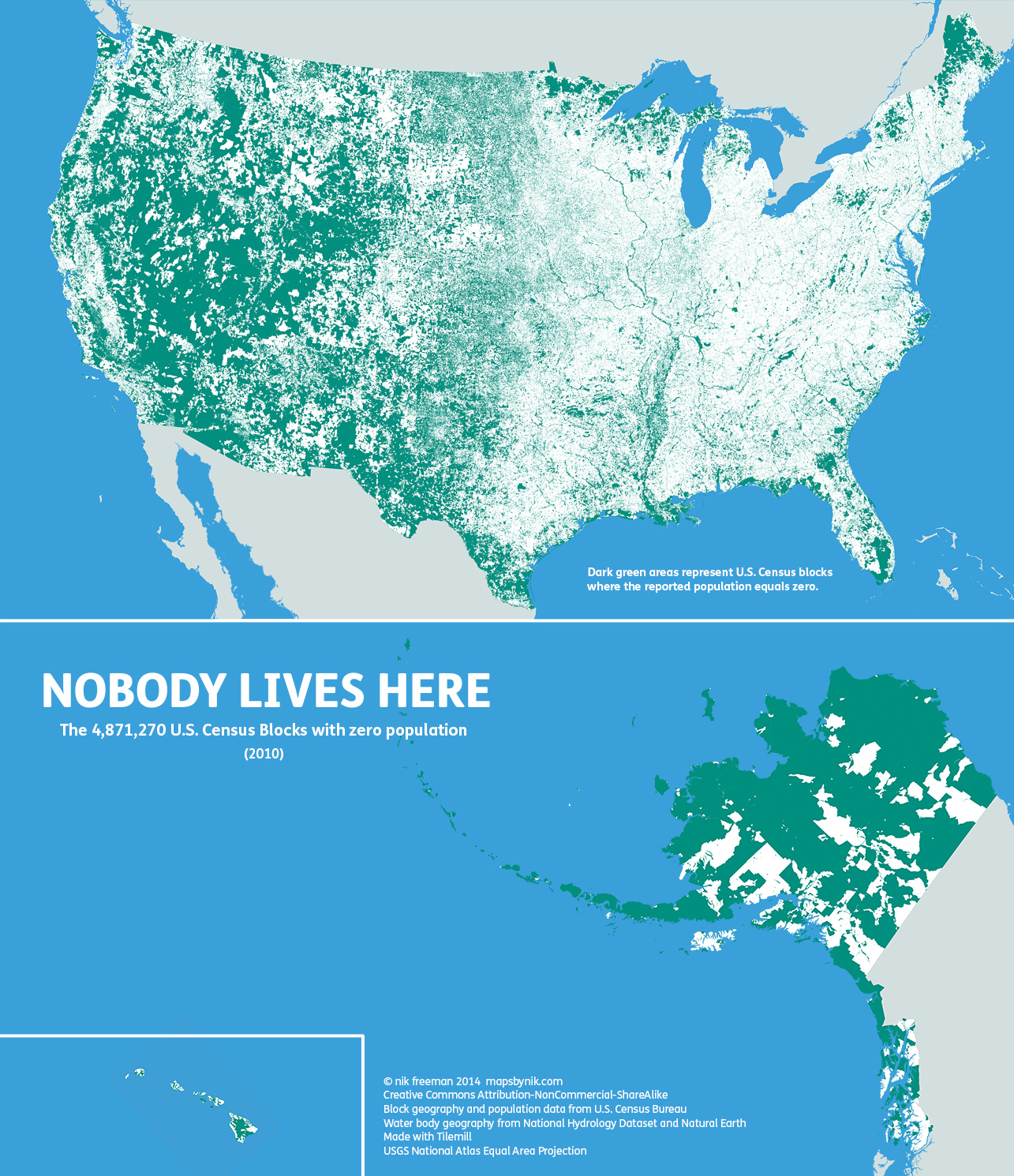
The accompanying text states:
> The map tends to highlight two types of areas: places where human habitation is physically restrictive or impossible, and places where human habitation is prohibited by social or legal convention.
And the creator states his purpose (emphasis mine):
> Ultimately, I made this map to show a different side of the United States. Human geographers spend so much time thinking about where people are. I thought I might bring some new insight by showing where they are not, adding contrast and context to the typical displays of the country’s population geography.
I for one found it very interesting to see the vast expanses of the U.S. that record no permanent residences. Of particular interest to me is the administrative effort that must go into maintaining almost five million census blocks that have no citizens to report!
Nothing in the post talks about population densities. All it talks about are census blocks with zero inhabitants. As such, the map seemed clear and clearly labeled to me.
Idaho has over 9 million acres of inventoried roadless areas. The largest of which is the Frank Church-River of No Return Wilderness, which together with adjacent wilderness and forest service land constitutes the largest roadless area in the lower 48 at 3.3 million acres. If you love the great outdoors, I can't recommend this area enough. It is a real treasure.
And of course it is only separated from the 1.3 million acre selway bitteroot wilderness area by the magruder road, a 101 mile dirt road built originally to aid in response to large wild fires. I live on the other side of it from Idaho near Missoula, MT. There is a surprisingly good startup scene here.
North Dakota is the only clearly discernible state boundary. Anybody know why that is? Does something about the legal regime of North Dakota really change the settlement patterns that much? Or is it some kind of artefact of the way that ND census block are formed, compared to the surrounding states?
> Update: On a more detailed examination of those two states, I’m convinced the contrast here is due to differences in the sizes of the blocks. North Dakota’s blocks are more consistently small (StDev of 3.3) while South Dakota’s are more varied (StDev of 9.28). West of the Missouri River, South Dakota’s blocks are substantially larger than those in ND, so a single inhabitant can appear to take up more spaaaaaace. Between the states, this provides a good lesson in how changing the size and shape of a geographic unit can alter perceptions of the landscape.
Yep, I grew up in ND, and my nearest non family neighbor was 7 miles away. This was pretty common. So if you parcel things up smaller than say 5 miles you'll miss people there pretty easily.
Yeah, it looks like they are setting the census blocks small on what is farm, ranch, park, and reservation land. The Red River divides ND and MN and there is space there because of previous moves from flooding.
Most census geographies aim for equal-ish population, so they vary widely in size. Blocks are a little different, though, and are designed to be a more or less nicely boundaried thing as well -- surrounded by streets with no crossings, etc.
It's pretty clear on the west coast of NoDak.
*edit:
After looking at it for a tish longer, I can see all three borders quite clearly. Being a North Dakota native may help.
Might be too late to chime in but not enough people know this:
Much of south Texas is shanty towns and illegal settlements, because immigration won't check documents until you are about 100 miles from the border. These people are largely ignored by the US population and not counted in census.
Drove across Wyoming the other day on the way to Denver and I could definitely appreciate that it was the least populated state in the US (or least densely populated). Lots of open space.
I'm a recluse and I've actually considered one day retiring to a state like Montana, Wyoming, or Idaho. This infographic just made my eyes light up. "Oh my god I can finally get away from everyone" I thought.
For this past long weekend I snowshoed into a remote lake and stayed in (and fixed up) a beautiful abandoned cabin. Ice fishing, star and northern light photography, wildlife viewing and beautiful sunshine. Didn't see a single person, and I would have been shocked if I did.
I cleaned out all the junk, repaired the window shutters, hung some plastic to catch water drips, put a new sheet of plywood on a table, built a new "coffee" table, re-hung the door on it's hinges and generally tidied up.
Remember, the daylight up here is already 6am-10pm, so there is tons of daylight for activities, and lots of the cabin work can be done in the evening, when the sun is setting but it's not yet dark enough for Northern Lights photos.
I knew you had the sun on your side but I figured the lack of a Home Despot within snowshoe distance was going to be a killer. I know from experience that having to recycle/repurpose materials can triple the length of time it takes to complete any project and on top of that you have to factor in the working solo 50% time tax. I am impressed.
Was the door rehanging due to some sort of winterizing or bear-proofing?
I don't know the history of the cabin, and I am trying to find out from old-time friends.
I suspect it was built in the '60s or '70s, likely a trappers cabin (most up here are). It was built with logs much too big to be from the Yukon though, so I think it must have been something important for them to import logs like that (likely from just down the road in Alaska). Which is confusing, because it wasn't on any important routes like you expect to find on, say, the Yukon river, or big lakes up here.
Judging from the materials, recent improvements and nails, books, clothes, stove, etc, I then suspect sometime in the 90's someone moved in for a summer and did a ton of work. New window shutters (built with screws indicating a cordless drill), new floorboards with paint, roof work, etc. etc. Also they conveniently left a bunch of brand new sheets of plywood and 2x4s out of the weather, and many thousands of nails. The only "visitors message" was from '98, written in pencil, which was conveniently left in a tin of nails for use in construction.
The door was very solid and clearly bolted and locked in many places long ago - the thing about locked doors on cabins in the Yukon is they tend to get smashed in by people, as this one had been. People up here prefer cabins be left unlocked so they can be used in emergencies in the winter (when it's -40) so 99.9% of cabins are not locked, and simply have a book that says "please use this cabin and treat it as your own - also leave a note in the guest book if you like". It's a great sense of community. So the door had been smashed in and was lying under a couple of feet of snow. The first night I was busy with everything else, so I just nailed up a sheet of plastic over the door in an attempt to make it air-tight. (I brought the plastic with me, having been told the cabin was a wreck)
After I dug out the door and got all the snow/ice off it, It was easy to line up the hinges and put a couple of big nails through to get it hanging right. It's possible it was knocked in by a bear (not common, but it happens), though I didn't see any evidence to suggest that.
Bears are awake now, but I didn't see any or any evidence of them yet this spring, and I covered ~40km on snowshoes
All in all, as you might be able to tell, it's a great sense of adventure to go to remote rivers and lakes and simply explore :) I'm working through the photos now, I'll post back here when they're online so you can see what I'm talking about.
Native wyomingite here - I wouldn't live anywhere else. Cheyenne (state capital) isn't even that densely populated and it's about the busiest city I'd ever want to live in. Here, life seems mostly laid back and relaxing where just a few tens of miles to the south in either Fort Collins or Denver, CO, life feels hectic and claustrophobic.
I'd call this city just about perfect, though - it's still in Wyoming, so there's still separation between people, but it's a quick hop skip and jump to a bigger city for any events in that area.
I don't know. I lived in Cheyenne for five years (nuke officer), and to this day, whenever I get caught in an afternoon, car door bending wind, I think of those days; the air continuously rolls down the Front Range whipping through town...but Vedauwoo was beautiful, and thankfully Ft Collins was just a hop away.
Vedauwoo is nice, and Laramie is a laid-back college town. I also like the more remote parts of NE WY, like Thunder Basin National Grassland. I have friends who are homesteading near Wheatland.
They purchased more than 50 acres of ranchland. It is a subdivided piece of a huge ranch that has never been developed. They had to "homestead" it in the sense of building everything themselves. The deed says it's 50 acres, but the prepared survey measured something approximating 55. They told me how much they spent on the property itself; I can't quite remember the number but I was surprised by how affordable it is. Of course, there isn't much in the way of services there but they do have satellite internet access and have built a house on the property, have a garden with an irrigation system, solar panels, raising chickens and some livestock, etc.
I have visited there and it's one of the few residences I've ever been to where you can do a full 360 degree revolution while standing on their property and all you see is nature except for their small prairie home...no other buildings, power lines, or structures owned by anyone else in sight. Also, the air there is wonderful; there's a faint scent of sage all the time.
Oh thank you. I didn't know anyone actually read those. I mainly started my blog to give myself a boost in confidence every now and then and help me get a 9-5 design job eventually.
Just so you know, Idaho is a very nice state in many ways. Largely the only real downsides are the lack of jobs and high culture. I've lived there in most of the corners and would be quite happy to discuss the state with you.
I did no such thing. I responded to someone's statement that he's a recluse with the suggestion that perhaps that's not a natural state. Somehow this is offensive?
Then I went on to make what I considered a positive and constructive suggestion, that assuming I did not understand the person, he might look in places other than zero-population areas for suitable but more convenient habitation.
I'm sorry you see that as "not OK." I see it as ridiculous that this sort of well-meaning input should somehow be so awful as to be unmentionable. But I seem to be pretty much alone there.
But why don't you think it's OK for the other poster to be a recluse? Like him, I quite enjoy solitude and that's one of the reasons I posted this. I spent a month working in a remote desert last year and found it the peace and quiet very restful, in contrast to the hustle and bustle of city life. I enjoyed the latter much more when I was younger but over time my tastes have changed.
I see no reason for you to project your standards of mental health onto other people, even if you don't share their inclinations.
And I see no reason for you to assume that my concern for another human being is somehow projection.
You like being alone. Congratulations. So does he. That's great, and I never said it wasn't OK. I tried to make suggestions that people for some reason didn't appreciate; that doesn't mean I was condemning him or his lifestyle (or your lifestyle).
Anyway, this is past the point of productivity. I tried, no one appreciated it, and I'm not going to apologize for other people's uncharitable misinterpretations.
An assumption I did not make. My statement about convenience was in reference to being around services central to population centers, e.g. medical facilities. Clearly most people here don't agree with me, but that does not justify projecting your own mistaken ideas about my position.
I have no idea what your comment was before it was deleted, but based on how defensive you've gotten since, maybe you should seek therapy for your anger management issues?
Drove from ND to Denver through Wyoming and felt very much alone in a lot of places. I thought ND between small towns was empty, but Wyoming was scary empty.
To put that number in perspective, I live on the border of Cobb County, Georgia, whose population as of 2012 is 707,442. This is one county outside the city limits of Atlanta (but not by much). While Cobb County is a metro Atlanta suburban county, it also has a large portion of semi-rural area. It blows my mind that more than an entire state's populace fits in a tiny (geographically speaking) county in a largely rural state.
Oh, I'm sure there are, I just think it's an interesting corner of Oregon that's worth pointing out because it's really unknown, but beautiful and fascinating.
And supposedly half the population that lives West of the Mississippi lives within 30 miles of I-5. Don't have the US Census loaded currently so I can't check it, but that does sound about right.
Given that half the population of the US is 156 million, and half that is 78, it's plausible, but a quick add-up of combined MSAs comes up short:
LA is 18.1 million, San Diego 3.2 Sacramento 2.2, Stockton 0.7, Portland 0.5, and Seattle-Tacoma 3.6. I get about 23.3 million total, which is still 54 million short.
SF-SJ-Oak adds another 8.4 million, but most of it is more than 30 miles from I5.
Checking by state confirms it:
CA: 38m, OR: 3.9m, WA: 6.9m. combined total: 48.8m. Still 30 million short.
Actually, west of the mississippi (and assuming all of Louisiana and Minnesota) the population is only about 130 million - so those three states are about 40% of that population. Given the rapid growth of texas, colorado and arizona, and Nevada (well Las Vegas) in the last 15 years, it wouldn't surprise me if those three states would have been over half the population west of the Mississippi not that long ago.
As for within 5 Miles of I-5.. probably not, but within it's area of influence, for sure - the western parts of those three states are pretty empty, even by my midwest trained standards.
If you shrink it even further still you'll find 100% isn't being occupied! That's assuming each person occupies only a point, or pretty close to. That's why this map is so misleading even if it is fascinating. The size of the blocks has a huge effect on the result.
But isn't the resulting image kind of inversely misleading? Ie showing less unoccupied space than existing? Most of the occupied blocks are only occupied in fractions, as you both say.
You get west of the western edge of the Gulf of Mexico. So yo don't get moisture coming north off of the Gulf. So the land not only gets more rugged, it gets drier. So you get less farming and more ranching.
The land gets a lot more rugged. About 98W is where you start transitioning from rolling plains to mountains, deserts and other features that are pretty incompatible with starting up any sort of permanent settlement.
I grew up in Maine. The area in green is rather rugged terrain. It's the end of the appalachian mountains with lots of sharp features cut by receding glaciers, then to top it off, it's very dense forest. Topo map (http://www.geomart.com/images/raisedrelief/me.jpg)
Large portions of that area are also owned by paper companies. They obviously use it for harvesting trees but also open it up for public use. That makes it sort of a quasi national park type area except that it's privately owned. There are also a lot of privately owned 'outdoors' cabins up there where hunters/campers go in the summer, and snowmobilers in the winter. Not many people 'live' there, but during some periods of the year there are a fair number of people around, particularly near the larger lakes.
It is a beautiful and relaxing area, I head up there once a year to go camping and 'unplug' from Boston for a week. It is somewhat refreshing to be 80 miles from the nearest paved road and 5 miles of canoe paddling from your vehicle.
The coast is about the only part of Maine that is inhabited. That particular dark green area is largely remote, quite harsh, and has very little infrastructure. North and west of there is the tiny sliver of inhabited Quebec, then go much further beyond and you're in some of the harshest, most remote land in North America.
If you're interested in what the area looks like, check out the Trans-Taiga Road as well as the (less remote) James Bay Road.
The vast majority of our population is scrunched into the southernmost quarter of the state. I'm not sure but I would guess Maine is the poorest of the New England states. Our economy depends very much on tourism and economic connections to the rest of New England, which means the state "faces" the south, in a sense.
Not a whole lot going on up in the north by comparison. Just forest and many many lakes which alternate between being frozen or mosquito infested depending on the season.
Maybe I'm the only one, but is anyone else impressed about the amount of populated areas in the country? It makes me wonder how long we have until we start shoving each other into the oceans.
A long time. Even the populated areas could be a lot more dense, and we wouldn't have people pushing each other into the oceans.
Hong Kong has a density of 6,620 people per square km. If the US was that dense, we could fit the entire population (317 million) in about 48,000 square km (the US has close to 10 million square km)
Of course, we probably couldn't have that many people living in that dense an area. But we do have a long way to go before we are pushing each other into the ocean.
Hong Kong's population density is actually even more impressive than that when you consider that large swaths of the land are either mountains or protected areas that developers are unable to build on. Many areas in the city are an order or magnitude or more higher - Mong Kok, for instance, has a population density up around 130,000 people per km/sq.
The chart only shows presence or absence of human settlement. Just because there are people there doesn't mean there are a lot of people there. Outside of big urban areas like SF, LA, NYC, and Chicago, the US isn't a particularly crowded place. I was born in Shanghai, China and went back to visit family about 4 years ago. I also lived in Manhattan for 3.5 years. Times Square cannot even compare to the absolute crush of humanity at Shanghai's Nanjing Street. Believe me, the US won't be filling up anytime soon.
Just have to point out that the population density is hard thing to talk about in the U.S. because the reality is that NYC is far more dense that any other city. We talk about a few cities as though they are equals when in reality it's NYC and then a giant dropoff to everyone else.
Also there's a perception of a few places as being the "big cities" even though population has changed a lot over the years. Perception hasn't changed. So even though SF is definitely dense, there are other places that are equally dense, like Miami, Philadelphia, and Louisville that people don't really think of that way. And then there are emerging big cities (but not necessarily dense) like San Antonio that people perceive as being small.
Western china is also sparsely populated. Heck, much of even eastern f china is mountainous and not suited to dense population. That there are people at all in these mountain villages is quite amazing. Anyways, the us and china are quite similar in the whole. Just china has many more people.
We'll fight each other over fresh water supplies long before we're shoving each other into the sea.
The looming water crisis is a particularly big problem in California, Arizona, and parts of the Southwest. Interestingly, farmland irrigation accounts for a bigger drain on water than almost all of the nearby cities combined.
Growing crops with desalinated water costs more for the energy to produce the water than the price of the crops grown. That's why desalinated water tends to only be used for domestic supply. The real problem is energy price.
So what are the average sizes of these census blocks? Assuming an average is at all indicative of anything, I'd guess that it was perhaps around 1 km2 on average (going by number of census blocks). I can imagine that pieces of 1 km2 of land being totally uninhabited would be fairly easy to come across a lot of places.
Came to ask a similar question. I love me some maps and data, but the post just assumes everybody knows what a census block is. More importantly, the shape and distribution of census blocks really affect the interpretation. The uninformed reader might assume census blocks form a regular grid, but since they don't, his or her interpretations will be wrong.
And as the note about the ND-SD border mentions, there are artifacts in the map that arise from the shapes and distributions of the blocks. Whether there might be few or many other such artifacts, the cartographer gives us no information to ascertain.
https://www.fort.usgs.gov/sites/default/files/products/publi...