I wish the MBTA was more transparent with this type of data and visualization. If they themselves charted things like this for the public, and then made commitments to improve (or at least not get worse) based on metrics that the community agrees are important, then I think that would be a significant move forward. The GM of the MBTA right now just doesn't seem to really care about addressing these issues in a clear and accountable way (ie. fire the people who cause systemic issues).
There are some absurdly obvious ways to improve the T. One study was done in NYC which showed that making the busses free would actually save them money, as the gas/time spent idling (and delayed) actually cost them more than fares. I wouldn't go this far, but I'd say that if there are 50 people in line to get on a bus, that they shouldn't charge a fare to just get things on-time. As-is, I see bus drivers hold up things all the time for one person counting their nickles to get on the bus; that is simply inefficient. - http://www.economist.com/blogs/gulliver/2013/06/fares
Other places like Park St could be massively improved. Have one side of the platform (outer side), be the side that people get on the trains from, and the center area be the place that people get off the train. This would streamline foot traffic in the station. Make some stairways one-way to additionally streamline foot traffic.
For some reason, Boston never planned for bypass capability, for trains to be able to get around stations, run express or in parallel. NYC did it, and it helps a great deal with construction, disabled trains, express trains, etc... Not all the the T is 100+ years old, and for newer lines/stations such certainly could have been done.
I could probably sit here all day and think of basic improvements to help with things like this, but it takes the T forever to implement anything. How many years did it take to get the signs on the Red/Green lines operational for tracking train positions (a trivial problem in my mind, from an electrical and implementation side. These days, I'd just use iBeacons...)
And, you might have missed at the bottom of the page... here's a realtime version: https://mbta.meteor.com/
I’ve lived along various parts of the Green Line for 10 years now, so I hate on the T as much as the next guy, but trivializing the MBTA’s (very real) problems is total bullshit.
> I could probably sit here all day and think of basic improvements to help with things like this
You probably could, but armchair-quarterbacking on HN isn’t going to help anything. Take your ideas over to http://www.meetup.com/Code-for-Boston/. I’m sure they would love the help.
If they read comments from the public and acted on them (or at least considered them), it would help. You're right that actually doing something however is more helpful, but for the things that actually need done to the T there aren't really coding things we can do to help change things.
> I wish the MBTA was more transparent with this type of data and visualization. If they themselves charted things like this for the public[…]
Disagree!
The MBTA provided the data, which is as transparent as it gets. Getting analysis from a 3rd party provides a level of impartiality that this data needs.
It took them years to decide to release this data in a usable format, which surely they had internally for the longest time. I agree that 3rd party work is essential to check them, but it seems they aren't aware themselves of these things... or at least not to the public. The GM just spins happy stories.
> For some reason, Boston never planned for bypass capability, for trains to be able to get around stations, run express or in parallel. NYC did it, and it helps a great deal with construction, disabled trains, express trains, etc... Not all the the T is 100+ years old, and for newer lines/stations such certainly could have been done.
I used/use the D.C. metro system since I was a kid and this has always been an issue with the system. As it gets older, the system gets more unreliable (and constant budget issues from having to span 3 territories continue to defer basic maintenance) it's getting worse and worse. During the summer you're lucky to get 5 continuous days of trouble-free service. Even worse, issues on unrelated lines spill over onto working lines and the entire system grinds to a halt. Even worse, the ride is pretty bad, it's as bumpy as the NYC system, which you wouldn't expect with it being half a century newer. But it's the maintenance that's at fault for all that.
But NYC is unusual in that it has such redundancy built into it, I don't think even other large systems of similar vintage (London, Paris) have such a robust system. Doing so these days is likely so expensive it'll just never happen elsewhere. Even the newest line being built for the D.C. system is single tracked.
That being said, NYC still has issues, probably stemming from it being basically ancient (so does London and Paris). It's a noisy, uncomfortable ride, with stations seemingly randomly closed and a service schedule that's pretty opaque once until you've used it for a long time.
Recently, I was in London, and almost everyday there was some kind of outage on the Tube. It's fortunate that stations are close enough, and the bus system so good, that you can work your way around it without too much fuss (and the TfL did a remarkably good job getting employees out and about to redirect people). It's just part of being an old system, the maintenance becomes pretty heavy.
I worry about the gleaming newer systems in Asia. Huge, complex, mostly built within the last 30-40 years...mostly single tracked like everywhere else. What's going to happen when these systems are more than 100 years old like the MTA or the Tube?
FWIW, even newer parts of the NYC system aren't getting bypass capability -- the initial portion of the second avenue subway will be double-tracked when it opens in a few years; they even cut out a planned storage track (which could at least have been used to get disabled trains out of the way) to save construction costs.
I can almost guarantee that if you add up lost productivity over the next 50, 100 or whatever n years, the loss in monetary value will be far greater than the construction costs amortized over the same period.
There actually is a secondary system to the Paris Métro that runs faster and makes fewer stops called the Réseau Express Régional: http://en.wikipedia.org/wiki/RER
I found this part of the Wikipedia article especially interesting:
> Used for leisure journeys, the RER has had a major social impact. By bringing far-flung suburbs within easy reach of central Paris, the network has aided the reintegration of the traditionally insular capital with its periphery.
The RER is a bunch of separate lines; of course when you have two lines covering similar routes one can (to a certain extent) relieve the other. What NY has is different: 4-track lines everywhere, allowing them to do maintenance on one track pair while keeping the other running.
"Used for leisure journeys, the RER has had a major social impact. By bringing far-flung suburbs within easy reach"
That's what suburban train systems usually do, isn't it? You get on the train in the middle of the city and in 40 minutes there's lakes and forests and everything.
When new systems age, something similar to Chicago is likely to happen, which just closed a 1969-vintage line for 6 months to do a major reconstruction:
http://en.wikipedia.org/wiki/Dan_Ryan_branch_(CTA)
I'm just concerned about the time-value of money thing and the utility of cheap labor when it's available. It really does get more expensive (relatively) to do this stuff decades later.
>'For some reason, Boston never planned for bypass capability, for trains to be able to get around stations, run express or in parallel.'
I'm not at all familiar with Boston, but I know a fair bit about DC and the main issue is pretty straightforward - tunneling is monstrously expensive.
Combine that with a lack of dedicated funding and the competing interests of DC / MD / VA for what funding there is you'll hear 'premature optimization' faster than an HN thread suggesting a three tiers for a startup web site.
That's before you consider that the system is shallow enough near the center to run alongside anything with three or more basement levels and the fallibility of switch gear.
it is even more expensive in parts of Boston known for having the worst problems. The Green Line (which isn't even analyzed) runs through Back Bay, which is largely landfill[1] without very good engineering properties. Combine this with running under many buildings that are National Historic Landmarks[2][3][4] and have shown shifting with bits of construction such as adding an elevator[5], these tunnels are pretty much impossible to expand.
>I wish the MBTA was more transparent with this type of data and visualization. If they themselves charted things like this for the public, and then made commitments to improve (or at least not get worse) based on metrics that the community agrees are important, then I think that would be a significant move forward.
As someone who grew up in Massachusetts and left for NY for a while then came back the public transit in this state frustrates me.
They haven't extended the T since I think the 80s (Not counting those silver line buses). The green line extension is coming anytime now....
Massachusetts has a hard time getting stuff done, but it does seem to happen eventually (convention center, new garden, big dig).
Part of the problem is the lack of state (or county which barely exists here) control to push stuff through. The red line doesn't go to Arlington because they didn't want it. The garage at Ailewife station doesn't have enough spaces and the T doesn't have the money to expand parking to meet demand.
You are right, you can sit here all day and come up with improvements.
They haven't extended the T since I think the 80s (Not counting those silver line buses).
The commuter rail system has been extended (Worcester, Old Colony) and those relatively simple expansion ran into huge obstacles because of community and environmental concerns.
The red line doesn't go to Arlington because they didn't want it.
Thanks to NEPA. The problem is trying to find the right balance between letting NIMBYs dominate the conversation vs letting the state push through a transportation project that destroys neighborhoods (a la the original elevated artery). If the problem was easy to solve, it would have been solved by now.
> Massachusetts has a hard time getting stuff done, but it does seem to happen eventually (convention center, new garden, big dig).
Heh, I was going to respond "but Assembly Square is moving so fast". Then I read the Wikipedia and saw that it was declared blighted in 1979, and didn't actually see much improvement until 2005. Construction on the new mixed-use development has been moving rather well over the past two years though, after the IKEA legal tango was finally resolved.
It actually wasn't completely horrible before they knocked in down in preparation for IKEA. There was a crappy movie theater which was cheaper than other local options. There was Good Times Emporium which was like a cheaper/crappier version of Dave & Busters. A variety of other big box stores, a K-mart.
Yeah, I already much prefer Assembly Row but it was useful from a bargain hunting sense.
As a developer working in the information industry in Boston, its like pulling teeth to get the MBTA to even respond to you. I'm blown away and inspired by the work done here. Well done to the authors and hopefully we can see some improvements for my daily commute.
> One study was done in NYC which showed that making the busses free would actually save them money
I wouldn't go that far either -- but why not decouple the functions of driver and ticket checker. This is already done in some systems and seems to work well. The people pay for their ticket at the station instead of the bus and stamp it themselves when then board (with a time stamp). (or avoid the process by buying monthly pass).
Then people can board directly through the back doors as well because the driver doesn't need to check.
Periodically, a ticket-checker or police-type of person comes through and gives fines (lets say $50) to those who don't have a ticket.
NYC does this right now on high traffic routes with their select bus system. You pay at the stop which then prints out a receipt that is valid on that route for 1 hour. Every so often inspectors board the bus and look at the tickets.
I'd go that far. Making the busses "free" would have a number of benefits:
1. Drivers might be in less of a hurry. MBTA busses frequently run red lights and/or sit in the middle of intersections creating gridlock. [Source: Pick any busy downtown intersection during rush hour and wait <15 minutes. Watch.]
2. In my (admittedly limited) observation, Boston bus riders tend to fall into two groups.
(a) Relatively affluent riders connecting to the T (the subway or trolley). The MBTA will still get some money.
(b) Relatively poor riders commuting solely by bus to one of the multiple jobs they're holding down per day. Consider this a kind of reverse sales tax.
The real problem with making buses free is that they basically become homeless shelters on wheels, especially in winter. This then means people don't take the bus, which means routes get cut back, which means yet more people for take the bus.
The best solution is to have cashless buses. In London, you can only use Oyster card or visa/MasterCard/Amex contact less payment cards to ride. It seems to have smoothed things considerably.
There are so many ways that IT could improve existing public transportation. When I was in the Boston area I wished for a service that would text me in the morning and say the next inbound trains are M,N,P minutes away. Depending on N I could stroll to the station or hustle to make it on time.
Even when I'm in a top-20 city (instead of a top-5), I could still be persuaded to take the bus if IT systems make it easy and convenient.
Believe it or not, there are people working for these systems who are both willing and capable of making that happen. Unfortunately, there's a trump card of paranoid ass-covering which routinely squashes such aspirations:
Terrorism
I worked with a transit agency was not just capable of sending texts, but had a surprisingly slick mobile-ready, web app for displaying realtime, animated schedules in 2008.
Someone got up in a meeting and said 'What if terrorists use that information?'
Today, six years later they don't have so much as a reliable API available to the public.
The MBTA does this these days although its main use is w/ the busses, where it has been a godsend. Since the bus tracking apps arrived busses went from something I actively avoided taking to using all the time to navigate the spokes in the system for exactly the reason you state. I can watch from my computer or phone until just before a bus is coming in and hurry on out to the stop.
The "counting fare" time thing may have changed recently. I got on the Green Line last week and my normal card had run out of reserve. I got a dollar bill out of my wallet, put it in the machine, and then started digging in my pockets for change. After about 10-15 seconds the conductor waved me away, telling me not to worry about it, and that the machine had already timed out.
Even without removing fares, offboard fare payment and a proof of payment system, as used on many rail lines, would speed up bus boarding and free bus drivers from having to serve as fare enforcement.
This is an incredibly beautiful visualization and analysis. The details are well thought out and easily discoverable.
Example: mousing over one of the lines and seeing the train position on the left map. An inspiration. Thank you!
One of the most significant issues in the Boston Subway system will not show up on a chart like this one. Right now, one of the busiest stations in the T system is shutdown with a planned closure of over two years.
Do you commute from the north part of the city to the west part of the city? Plan an extra hour per day for the next 30 months or so.
To clarify: it used to be possible to transfer from the Blue Line (serving the airport and parts of the north shore) to the Green Line (serving much of the inner metro west) at a single stop — Government Center, which is now closed for renovations.
For the next couple of years, getting from the airport or north shore to metro west is a Blue > Orange > Green transfer, which is definitely much more of a hassle. It would have been nice for them to leave a corridor open between the Green & Blue trains at Gov't Center, but then you'd have the liability of people walking around inside a construction zone.
I've never been happier that I work in Watertown.
Edit: the blue line does not serve Charlestown. Brain fart.
It's one of the really nice things about the Chicago Loop system - lines running to the city's inner core don't intersect at single points of failure in this way.
I wish that Boston's RGBOSi system did this. it would make life so much easier getting from one line to another.
Wow, I didn't realize how badly the Government Center station shutdown was affecting people. I presume you're talking about coming in on the Blue line and trying to get to the green. What's the best strategy- get out at State and walk to Park street? Or take the Orange to Downtown Crossing and walk the tunnel to Park?
Boston's really into transit-disrupting projects. Big Dig aside, the Longfellow is (mostly) out of commission for... three...years...
I used to commute from the Red line to the Blue line. In the mornings when I was in a hurry I would take the Green from Park to the now-closed Government Center and then pick up the Blue, but in the afternoons I would get out at State and walk to either Park or Downtown Crossing. As you say, it's only a few minutes' walk, and very pleasant to be in the heart of the city. Every so often in the morning the Green line was even delayed enough that it would have been faster to walk instead.
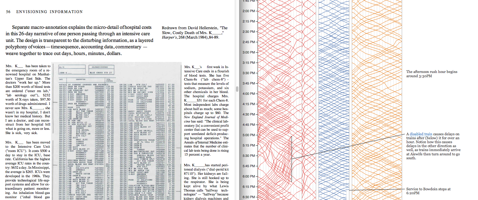
I just have to ask the OP...since one of the inspirations for this interactive's elegant design is Edward Tufte, did you take inspiration from his version of Harper's annotated hospital bill? Because that was the first thing I thought of when seeing the beautifully-done annotations alongside the dense subway arrival time data.
There are lots of influences from Tufte, the image you link was one of them for sure. We tried to incorporate other ideas like fully integrated text, numbers, and graphics and showing comparisons and causality. Bret Victor's work was also a big influence. If you are interested in what the design and implementation looks like and are in the Boston area there's a meet up this Thursday where we talk about building this:
http://www.meetup.com/Data-Visualization-in-MetroWest-Boston...
I just moved to Boston in May and this data almost perfectly matches up with my experience riding the T to and from the office each day. I really enjoyed the way this information was presented as well - great job!
Most of the data is collected from the MBTA's real time data feeds that list the current positions of all of the trains. The capacity data (who's entering and exiting the stations) is collected at the turnstiles and is not part of the MBTA's public API, we were able to get this from the MBTA through their developer relations program http://www.mbta.com/rider_tools/developers/.
I'm in the UK and the time on the chart seems to be displayed in UTC (which isn't even the timezone I'm in right now). The time shown starts at 10:15am when it should be starting at 5:15am according to the legend:
>Service starts at 5AM on Mondaymorning. Each line represents thepath of one train. >Time continuesdownward, so steeper lines indicateslower trains.
Has anyone else noticed this issue? (Arch Linux, Chrome: 35.0.1916.114)
UC Berkeley grad students did the same type of visualization 6 years ago with BART if anyone is interested.
Older tech back then so be warned, its in Flash.
Hadn't seen this before but it's interesting, their 'number of weekday riders' section is similar to the way we displayed station entrances over time. Thanks for the link!
There are some absurdly obvious ways to improve the T. One study was done in NYC which showed that making the busses free would actually save them money, as the gas/time spent idling (and delayed) actually cost them more than fares. I wouldn't go this far, but I'd say that if there are 50 people in line to get on a bus, that they shouldn't charge a fare to just get things on-time. As-is, I see bus drivers hold up things all the time for one person counting their nickles to get on the bus; that is simply inefficient. - http://www.economist.com/blogs/gulliver/2013/06/fares
Other places like Park St could be massively improved. Have one side of the platform (outer side), be the side that people get on the trains from, and the center area be the place that people get off the train. This would streamline foot traffic in the station. Make some stairways one-way to additionally streamline foot traffic.
For some reason, Boston never planned for bypass capability, for trains to be able to get around stations, run express or in parallel. NYC did it, and it helps a great deal with construction, disabled trains, express trains, etc... Not all the the T is 100+ years old, and for newer lines/stations such certainly could have been done.
I could probably sit here all day and think of basic improvements to help with things like this, but it takes the T forever to implement anything. How many years did it take to get the signs on the Red/Green lines operational for tracking train positions (a trivial problem in my mind, from an electrical and implementation side. These days, I'd just use iBeacons...)
And, you might have missed at the bottom of the page... here's a realtime version: https://mbta.meteor.com/