This headline could really use the word "hurricane" in it. I had no idea what Otis or Acapulco were, and my initial guess was wildly off: some sort of space probe experienced a catastrophic failure on the way to an asteroid.
Otis is the name of one of the Fat Bear Week audience favorites so that was where my first thoughts went but I was very surprised to imagine an “Acapulco, Alaska” near where he lives.
If I heard that Otis exploded after visiting Acapulco, I wouldn't really consider that unexpected, but admittedly that's only based on personal anecdata.
I guessed the correct Acapulco then hypothesized that Otis was something being transported by truck to there. I even thought that Cape Canaveral or a lab like CERN would be a more likely destination for dangerous things that people like us would care about.
I think we'll see more of this sort of thing. Weather models have been made in a climate somewhat different than the current one and those models are relatively accurate when modeling the past. As more data rolls in about anomalies like this the models will get updated and they'll become more accurate again in specific cases that are outliers right now, but they may end up slightly less accurate overall (due to the increased bandwidth of possible outcomes). This happens in almost every field where modeling is used to predict complex systems. You can't guarantee both great performance on past data and great performance on data that you haven't seen yet, there is always the risk that you've lost generality as you increased accuracy.
> So how did every reliable model we use miss this? That’s for graduate students and researchers to answer in the coming years, because I have no formal idea.
Would love to see followup on this. Wish there were some way to like bookmark or something and come back in a few years.
I'm one of the researchers on a new disease forecasting project, and I'm bookmarking this because we often use hurricane forecasting as an example of a level of accuracy we aspire to, so this is a really interesting breakdown.
The big miss here seems to be that not enough data had been seen yet to even know the envelope of what's possible. Without that there will always be inputs where a model breaks down. Disease modeling is also always going to have to contend with the fact that our historical data was collected when things weren't quite what they are today, for instance population numbers and densities are still entering uncharted territory compared to the past.
There's usually a mix of statistical models (some traditional time series methods, some neural network based) and mathematical models (i.e. SIR models). None of them fully capture all the dynamics we need to.
Detailed summary from interview:
• only 1 hurricane hunter flight was done into this storm.
• mexican hurricanes just don’t get as much reporting coverage (historically). For example for atlantic hurricanes, NOAA hurricane hunter airplanes have tail doppler radar, which provides good data to feed into the model.
• without detailed doppler radar, they had to fallback to satellite measurements.
• Mexico doesn’t have ground based radar coverage at all, like the US coast does.
This is the most likely answer. Since the atmosphere is a chaotic system weather models are extremely sensitive to initial conditions. A lot of the improvements in weather forecasts have come from better data assimilation for better initial conditions.
too late to edit my comment, but after more reading it seems like mexico does have land radar along the coast, but it’s a much smaller network compared to the US coast. So for this particular hurricane, there was lack of coverage.
> Otis intensified so quickly that it basically outran the ability to measure how intense it actually was.
We're working on this problem at Care Weather (www.careweather.com). Current wind sensing satellites only measure ocean surface winds once per day. They're too expensive for governments to build additional satellites for more frequent refresh. We're lowering their cost by three orders of magnitude and launching a constellation to get hourly updates.
For me it is completely relevant to the article because it make it impossible for me to read for no legitimate reason.
Even if the site was down for everyone I would comment. Lots of people comment about “hug of death”, for example, and I find it very useful. I know it is not me and I can find an alternative.
And since it’s not down for everyone, only a few, for a new, odd, technical reason, I find it even more relevant to comment about it.
Just like it is useful when people comment when a site is not accessible from a certain country, like BBC sometimes or some YouTube video.
I see these comments often on HN and I always find them useful. They also usually are among the top comments, so likely not downvoted.
That said, I was premature in editing the comment to show my surprise in being downvoting. That, indeed, is against HN etiquete and also it was just some temporary state, since I got many more upvoted since then.
If my ISP was hosting the page, sure. The article is the thing. And if you can't read the article due to false positives around how the article is hosted, how in the hell is that irrelevant? "I got mine, screw you." is a disappointing lifestyle choice.
But great news, we're on HN, so maybe jgrahamc or eastdakota can show up and explain why it's totally normal and fine that their product prevents random people from reading about the causes of natural disasters.
I've always found the relative unreliability of meteorological predictions fascinating. A lot of the time they're spot on (even the notorious "probability of precipitation") and the way we're able to track and predict storm paths is so impressive.
But from time to time we get an event like this, and it really underscores how little we really know. The sheer complexity of the phenomena / the theory we use to contain and understand them, it just seems to misfire spectacularly on occasion.
In a fantasy world, I would like to see weather forecasts that reach several months out, with high reliability. Mapping winds, precipitation, etc, with high spatial and temporal accuracy.
Perhaps I'm just misunderstanding what you're saying but when it says "30% chance" what it is actually saying is "there's a 100% chance of rain in 30% of the coverage area".
“It feels like this was a combination of bad luck, bad timing, and bad placement. And it just so happened that a metropolitan area with over 1 million people was in the way.”
We did find clay tablets with inscriptions from earlier civilizations.
If all papers, books and newspaper gradually go digital, just electric charges or magnetic blips in racks - few thousand years down the road our civilization would be virtually traceless or at least those parts of it.
Hurricane Otis Discussion Number 10
NWS National Hurricane Center Miami FL EP182023
400 PM CDT Tue Oct 24 2023
Otis has undergone very rapid intensification today. An eye became
apparent on visible satellite images only a few hours ago, embedded
in very deep convection. An Air Force Hurricane Hunter aircraft
penetrated the eye around 1900 UTC and again around 2000 UTC, and
found that the maximum sustained winds had increased to near 110 kt
over a very small area near the center, while the central pressure
remarkably dropped around 10 mb from the first to the second center
fix. The intensity of Otis is well above the Dvorak satellite
estimates, and again underscores the value of aerial reconnaissance
in monitoring hurricanes.
Otis should remain in an atmospheric and oceanic environment
that will be conducive for further strengthening later today and
tonight. Vertical wind shear should not be too strong, with SSTs
near 30 deg C. Based on the observed changes, the short-term
official intensity forecast remains above the model guidance. The
system is now forecast to be at extremely dangerous Category 4
hurricane status by the time it reaches the coast of southern Mexico
late tonight or tomorrow morning. After landfall, the system
should weaken rapidly over the mountainous terrain of Mexico.
The hurricane continues on about the same heading, or around 330/7
kt. For the next couple of days, Otis should move between a
mid-level ridge to the east and northeast and a trough to its
northwest. The official track forecast is about the same as the
previous one and is a little faster than the dynamical consensus.
On this track, the center of the hurricane will make landfall
within the hurricane warning area late tonight or early Wednesday.
For a weather forecaster this is a really strange take.
Anybody who understands what the big words 'climate change' mean, could have predicted this. HAVE predicted this. I personally have predicted this and I'm not even a weather forecaster, I just know what chaos theory is.
Adding energy to the system produces a wider range of possible outcomes. This is absolutely one of the possible outcomes.
A few degrees less warming and it might not have been possible.
Chaos is STRANGE. It's sensitive to initial conditions. One of those conditions is the total energy in the system. This is what happens when you add a few degrees to the whole planet. It'll act normal, sort of, maybe for quite a while… then bam.
Because this is what you get when you add energy to a chaotic system the size of a planet, and it will happen again. We just got a picture of the new range of possible event… or of something WITHIN the new range of possible event, which by no means is guaranteed to be the most dramatic climate outcome currently possible.
This was probably on the high end of possible events but might not even be the most extreme thing that can now happen with this level of climate energy.
While I admire your ardor, and agree with you that anthropogenic global warming is a serious problem, your explanation lacks a specific mechanism, and the disrespect you show towards the experts is reprehensible.
I found these facts in the article interesting:
- This is not actually unprecedented -- hurricane Patricia in 2015 did the same thing, more intensely.
- "Sea surface temperatures were close to 31°C over Otis’s path, which is a few degrees above normal. While not the primary cause of Otis’s rapid intensification, they did not hurt."
- Unusual placement of the hurricane relative to the jet stream seems to be the main cause
And even if completely true, it’s a useless factoid - we need to understand the physics of how these things work and are working and are changing if we want to continue to predict them accurately.
I must agree with you about disrespecting the experts. All of the best models created by the best meteorologists/climatologists suggested this wasn't going to come to pass. This was an extreme happening and brushing it off as rudimentary chaos theory is not useful.
Some of the weather people I see on Mastodon were talking about how this was a freak happening, but the article helped me understand that better. Forecasting hurricanes has gotten remarkably good, so this was surprising to me.
My reading of the article was that this (and most above average hurricanes these days) was probably due to climate change, since the ocean was warmer than usual, etc. However, repeating that isn’t particularly interesting. In other news, it is 2023.
The interesting question then is why all the models screwed up so badly. Is it because climate change means the model is now inaccurate, or was this within the baseline (no climate change) error rate of current weather prediction technology?
Quoting the article:
> This rich warm water did not hurt matters at all.
> So how did every reliable model we use miss this?
My guess is that if the model accurately represents all the realities being modeled, and if they ran the simulation enough times, they would get Otis in the model. It's very easy to get chaotic behavior out of such a model, or even simple circuitry.
At that point the question is not 'can the model do a run that produces Otis', because at that point it can and does, one run in ten thousand.
The question is, do the forecasters refuse to mention that one run of the model that produced that result. What seemed to happen this time was, not enough data or attention, and nobody ran their model enough times to produce the Otis result in the model. I don't think anyone saw it and discarded it, I think it didn't show up in anybody's runs of their models.
Odds are good that it COULD have, if the models are any good. It's just unlikely.
I agree with all of this except the first sentence. Weather people understand all this too, but forecasters were genuinely shocked by the speed of the transition from tropical storm to cat 5 - a process that they're used to observing over days suddenly took place within hours. Knowing a thing and seeing/experiencing it directly are very different.
I'm shocked myself by the degree of devastation, and suspect the reported death toll is low. Some of the damage can be ascribed to corruption and lax building codes, But the sight of multiple recently constructed high rise buildings completely trashed has to be sending a cold chill down the spines of insurers and emergency planners.
Best estimates I've found to date: [ EDIT: 0.6-0.8 ] * Petawatts * of extra energy circulating in the atmosphere as a result of anthropogenic changes to radiative forcing.
For the people who still argue with the use of watts, despite that being a standard for this, here's the author of the above link on this point:
> Note: Before anyone complains, I’ve deliberately conflated energy and power above, because the difference doesn’t really matter for my main point. Power is work per unit of time, and is measured in watts; Energy is better expressed in joules, calories, or kilowatt hours (kWh). To be technically correct, I should say that the earth is getting about 300 terawatt hours of energy per hour due to anthropogenic climate change, and humans use about 16 terawatt hours of energy per hour. The ratio is still approximately 18.
Out of interest, you can also convert it to calories. 1kWh is about 0.8 million calories. So, we’re force-feeding the earth about 2 x 10¹⁷ (200,000,000,000,000,000) calories every hour. Yikes.
With regard to your edit: take a look at the note at the end of the article you are quoting, where the author acknowledges being sloppy with respect to units. Here, he says anthropogenic climate change is heating up the Earth by 300 terawatt-hours per hour (which is, of course - and more simply stated as - a rate of 300 TW or 0.3 PW). Therefore, while it would be correct to say that this results in an extra 0.3 petawatt-hours every hour, this is not the same as nor justifies the statement "...0.3 petawatts of extra energy circulating in the atmosphere as a result of anthropogenic changes...", which is incoherent.
As for "1 order of magnitude (out of 16!)", the "out of 16" is meaningless - the number 16 is merely a consequence of the arbitrary choice of unit size. Your original figure was simply off by a factor of ten, in any units.
Radiative forcing is measured in watts per square meter. If you compute the total surface area of the earth [0] in square meters and that by multiply the radiative forcing number, you get watts.
[0] technically some layer of the earth between the ground and whatever you define as the edge of the atmosphere.
Next time you might just apologize for incorrectly using the word "energy" when you meant flux, and for being off by an order of magnitude... The defensive stance is not a good look.
Do not be bamboozled by the attempt to insinuate that it is you who has misunderstood something here (for more details, see some of the other replies.)
> 0.6-0.8 * Petawatts * of extra energy circulating
What is that as a percentage of total energy circulating? The number by itself is meaningless - the Earth is large, it has a lot of energy, that's not news.
I can't find reliable, straightforward numbers for the total amount of energy in the atmosphere. Reddit provides one pretty believable number of the amount of energy required to raise the atmospheric temperature by 1C: 3.7x10^21 J [0]
Taking my main source's figure for the number of calories per hour that we're adding (2x10^17 calories aka 4x10^17 joules), that suggests that we are causing enough extra heat to be retained to raise the atmospheric temperature 1C every 9000 hours or roughly every year.
The post is written in the context of weather models, not just the idea of climate and weather and what is possible. It is expected that this is possible - but none of the models currently in use for short term forecasting showed anything close to what actually happened.
It is a set of AQ-9 climate task force minutes. In the end, they conclude:
——
AT A 3% PER ANNUM GROWTH RATE OF C02, A 2.5°C RISE BRINGS 2
WORLD ECONOMIC GROWTH TO A HALT IN ABOUT 2025.
Even If this estimate is grossly wrong it Is still probable that
• WHETHER THERE ARE GROUNDS FOR IMMEDIATE RESPONSE TO THE THREAT DEPENDS ON THE VALIDITY OF THE LONG MARKET PENETRATION TIME CONCEPT.
• EVEN IF THE LATTER IS APPLICABLE, PRESENT DAY SIGNIFICANCE OF
THE IMPACT DEPENDS STRONGLY ON CHOICE OF A FUTURE DISCOUNTING FACTOR.
• NEED FOR IMMEDIATE POLICY ACTION HINGES ON THESE LAST TWO
FEATURES.
—-
The document also says that back in 1980, there was no leeway to wait to take action to mitigate climate change. Instead, they ended up spending unprecedented amounts of money on disinformation campaigns and in support of climate change denying politicians in the 1990s and afterwards to prevent action from being taken.
I guess their discount factor valued their grandchildren at ~ $0.
It is strange, but it’s not. My friends keep asking me why it seems like the weather predictions are always off lately. I tell them because they have no climate models for the state of the climate that we’re living in right now. They’re all based on past climate.
so this weather forecaster is just doing the same thing, he’s trying to predict future events on past performance.
What they need to do is start looking right in front of their face like you said.
And they need to get some testicles and start screaming that this is a problem at the top of their lungs. And then they need to quit their jobs at these network companies that all advertise for fossil fuel companies.
> no climate models for the state of the climate that we’re living in right now
That was the overall impression I got from the article: model after model predicted unremarkable intensification, and they were consistently wrong.
Out models are only as good as the input parameters, all of which are based on data from a past that no longer applies. Is there a way to apply climate change modelling to short-term weather modelling? Change the forecasting from "we expect such-and-such to happen because that's the most common case over the past 50 years" to something like "in the past we'd expect such-and-such to happen but including more recent work we expect a different thing"?
Yes. And they'll be doing just that. They couldn't even be modeling this without modeling chaotic systems: their models are chaotic systems too. With another model, the Otis event MIGHT have appeared, or might have appeared one run in a hundred.
With their current modeling, the Otis event might have appeared in their model one in a thousand runs, or one in ten thousand, depending on if they're accurately capturing the energy state of the system. They might've discarded it if it came up, as a glitch.
When real life glitches you don't get to re-run the model for more optimistic results.
I don’t see how taking advertising dollars from fossil fuel companies affects anything. It’s not like we’ll suddenly stop burning carbon if we stop oil and gas companies from advertising. The demand for oil will still be there. We need to make alternative energy sources cheaper than fossil, then demand will plummet.
We could do a lot by removing the trillions of dollars in subsidies which those companies receive, however. If the price of oil went up, people would scale back usage and alternatives would have an easier time, both outcomes which the fossil fuel industry has spent a considerable amount of money preventing.
I also noticed that but have assumed it's because of a change in reporting methods. It's hard to find a forecast that includes the confidence level of a prediction. The bbc weather forecast used to show the % chance of rain for example. Now most apps and websites just show a grey cloud.
One problem: if you acknowledge climate change on air, you’re risking a lot of flack and even violence from people who are steeped in right-wing science denial:
I feel like acknowledging climate change on Hacker News can produce similar reactions :)
I stand by literally everything I said, and would add that I expect another event, let's say half an order of magnitude more horrific, within five years.
Due to the nature of what chaos is, there's no telling where and when: could even come out of seemingly nowhere. But it's latent in what the situation is, and is the expression of what chaos means. And when the global system was that few degrees cooler, the upcoming event (or Otis) could not have happened.
Oh, I’m not arguing the urgency. I just think it’s important to remember that other people aren’t perfect manifestations of our ideals, either: they get scared, they have other problems taking up their attention, etc. It does mean we should all be pushing back against the rise of the right-wing stochastic terrorism which has been disturbingly normalized lately.
This guy is apparently an actual meteorologist, not just a TV weather forecaster personality. The vast majority of actual meteorologists are not working in front of a mic or camera.
I agree with you and think the downvotes are unfair. That said it doesn't help to just wring our hands about it.(Yes i know you weren't. You were just pointing out it could've been prevented).
Modelistas continue to struggle with infrequent events. To joke, if they were good at this kind of thing, they'd be in finance (but I'm rolling my eyes at myself even going for this cheap shot).
Same way game dev struggles to get good programmers because they all work for FAANG?
That's sarcastic, of course. There are a ton of world class programmers working in game dev. And a ton of world class mathematicians working on climate change. Not everyone uses money as their main motivation. Many people choose careers out of passion, or for the good of the world. And the world is a better place because of that, even if those people drive less shiny cars.
> Anybody who understands what the big words 'climate change' mean, could have predicted this. HAVE predicted this. I personally have predicted this and I'm not even a weather forecaster, I just know what chaos theory is.
This is a bit of a strawman. It's not that "no one thought this was possible".
We've known that we will be seeing storms that are larger, stronger, and faster forming than what we've seen before.
It's not been known that our current forecasting tools will be 100% useless in predicting when those much-worse storms would form. That's what was shocking; not just the rate of intensification, but that it failed to be predicted at all, so soon before the event happened.
I think it's wrong to imply that the current tools are 100% useless. I've seen a guy on youtube drawing on apparently elaborate weather models from multiple sources and they're just the sort of thing that would highlight the risks.
This guy (Ryan Hall (y'all)) has repeatedly highlighted the high sea temperatures in the Gulf of Mexico, stressing that they could produce rapid intensification of hurricanes, several times this season. The times that he drew this to his viewers' attention, the giant storms didn't happen.
This time, in the Pacific Ocean, in a different location not covered by his audience demographic, under the same conditions he's been highlighting right down to the warm ocean waters, the giant storm did.
Our tools are NOT useless, much less 100% useless. We're looking at windows into chaos. The rules are just different. A guy like I mentioned has to be concerned with crying wolf if he repeatedly warns against a super-storm that fizzles, but he's gonna keep doing it if he's honest, because he knows there will come a time when he calls it and is giving a warning for something that will come as a surprise.
You can SEE the conditions and go 'uh-oh'. Our current forecasting tools show these conditions, pretty well. You simply can't be certain which will turn into an explosion, and which will fizzle.
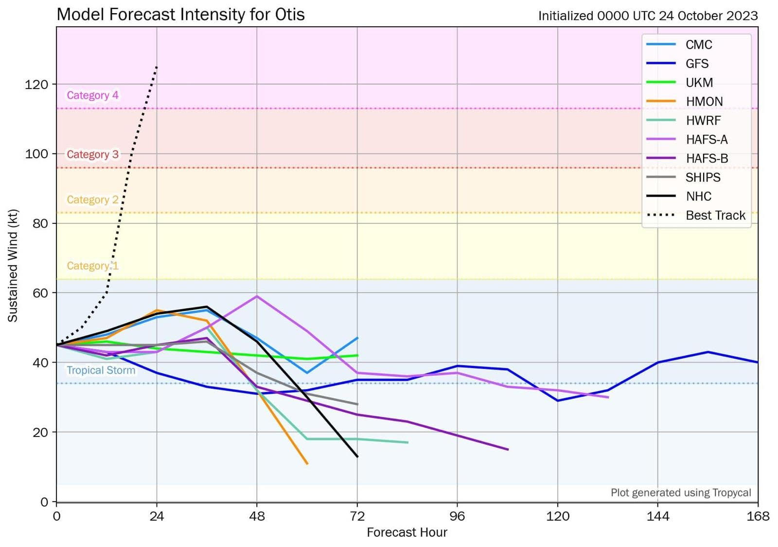
That's nine different prediction models, of which zero predicted anything resembling reality.
Sure, there was less data available than in other areas. Sure, there was less ground radar. Sure, fewer eye flights were made. But there have been other storms with a similar dearth of data; never before have all predictive models been so very wrong.