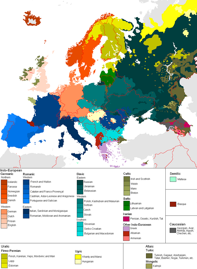
Basque and Briton are minoritary too. (BTW, it's very funny that Basque is listed without a heading, but it's very true. It's related to nothing else, and nobody knows where it comes from.)
It seems that where more than one language share one territory, the area is colored with the language that is more 'traditional' or specific to it, even if other ('invading') languages have demographic majority nowadays.
With that criteria, they could have expanded the area for Franco-Provençal quite a bit. Also, I think Astur-Leonese would deserve its own color rather than being incorporated into the Castillian group.
This is more realistic in assessing majorities and more politically orthodox, but not any more correct IMO. Ignoring minoritary languages altogether is no less of a lie than presenting them as if they were predominant. The map sticks to political frontiers rather than language areas. Also, I don't know why it doesn't recognize Asturianu, a language co-official with Castillian, while it does recognize Basque, which is minoritary and co-official too.
In that map we see that the Building Nation efforts in France and Great Britain have been more 'successful' than in Spain. So, while it's common in colloquial settings to use the name "Spanish" to refer to Castillian (even the academy of the language calls it "Lengua Española"), it's an aberration in a technical document. It would make more sense to call English Unitedkingdomish.
Looking at the shape of Holland, I'd say early nineteenth century. Holland's shape has altered dramatically in the last centuries, so it's a good test. Here are some historical maps for comparison: http://www.zum.de/whkmla/histatlas/lowcountries/haxnederland...
The shapes of the Iberian and Italian peninsulas have not changed much, and they look very inaccurate in that map too. I don't know if Holland's shape is a reliable indicator, considering such noise.
With single color regions, that's impossible. E.g. you can't show the geographical extent of both English and Irish if there are places people speak both.
I was serious when I asked if this map was from 1750. It looks about right for that, at least for the western European countries whose history I know well. (I can only guess about all the ethnic pockets in Russia).
I don't think Occitan had shrinked that much before the French Revolution?
My guess is the author is assuming that everyone knows where the dominant, 'imperial' languages (English, French, German, Spanish, Russian ...) are spoken, and aims to represent the deltas from those. Either that, or it has an exaggerated anti-imperialist bias.
With respect to Eastern Europe the map is complete BS. If they are claiming that East Ukraine speaks Ukrainian, they should mark Northern Ireland as speaking Irish.