I feel like another jarring comparison could be made not just by centering the red area on a low-population region, but by choosing red counties by population (allow discarding some populated red counties) you would have an even larger red area.
It might break the visual simplicity of this map though.
No, because we don't colonise the solar system using the surfaces of planets and moons — we do it by mining asteroids and building giant rotating habitats. There is enough material in just the asteroids alone to build habitats with a land area of millions of times the earth.
Look up the work of Gerard K. O'Neill or John S. Lewis for details.
Yes to this. Most of the spherical bodies in the solar system are so inhospitable that making a spinning cylinder full of air is actually much easier and more useful.
Depends on if you include the oceans. Mars is not that big, but lack of oceans more than makes up for it. On top of that we mostly ignore huge chunks of the land mass like Antarctica.
As soon as I saw the font I was like, it's either a blatant ripoff of xkcd or he just didn't cite it. Not sure why he didn't just add the URL as a caption.
The gas planets are complicated. They most likely don't have anything that could be called a well-defined solid surface beneath all that gas. We really don't know the details, but Jupiter and Saturn are thought to be something like this:
* Gas, mostly helium and hydrogen with trace amounts of other gases
* Cloud layers of ammonia, ammonium hydrosulfide, and water.
* More gaseous hydrogen and helium, lots and lots of it
* Hydrogen and helium in the form of supercritical fluid. Above the critical point there are no distinct liquid or gas phases.
* A thick layer of liquid metallic hydrogen. Really exotic phase of matter; huge currents flowing through it are thought to cause Jupiter’s extreme magnetic field.
* Finally, a solid core of some sort, not much is known about it. At those pressures and temperatures it must be pretty exotic. It may not have a well-defined boundary; hot metallic hydrogen is thought to be a ridiculously good solvent.
Uranus and Neptune are different; they're usually referred to as "ice giants" these days. Beneath the atmosphere they are thought to have a thick mantle made of various exotic hot ices (mostly water, ammonia, and methane), and beneath that a small silicate/iron-nickel core.
We're accustomed to associating the word "ice" with temperatures less than 273 K, the freezing point of water at 1 bar. It takes even lower temperatures for ammonia or methane to solidify. But it's definitely not freezing deep within a planet, the temperatures are thousands of kelvins! However, the pressures are from thousands up to millions of bars, which is plenty enough to keep pretty much anything solid even at those temperatures.
The allotrope of solid water we're familiar with is called ice I_h (Roman numeral "I" followed by subscript "h" for "hexagonal"). It has the interesting and vital property of being less dense than liquid water and thus you cannot get ice I_h by compressing water. But there are many other, more exotic phases of ice, most of which are denser than liquid water and can thus form under extreme pressures. Indeed, in a sense they're not that exotic after all, seeing that almost all the water in the Solar System is in the form of high-pressure ices!
Its existence was predicted in 1935 and it’s still pretty theoretical. But it’s pretty much the only thing that could explain Jupiter’s magnetic field. Just last year experimentalists claimed to have produced metallic hydrogen in a diamond anvil, but those results are under some scrutiny and AFAIK haven’t been reproduced yet.
I've seen a quick-and-dirty summary of how to think about bonds that goes like this:
- An ionic bond forms between two atoms, one of which has too many electrons and one of which has too few. They balance.
- A covalent bond forms between two atoms, both of which have too few electrons. Some electrons are shared between both atoms simultaneously, bringing each up to quota through the simple magic of double-counting.
- A metallic bond forms "between" some number of atoms which all have too many electrons. The surplus electrons roam back and forth freely around the metal because their home atoms would prefer them to go away, allowing the metal to carry electric current.
This model is supposed to explain why you can basically combine arbitrary metals in arbitrary ratios and still get a metal.
It also seems like it predicts the existence of metallic hydrogen, in that a normal H ion is positive. Does that actually make sense?
My understanding is they don't have solid surfaces as far as we can tell. Both the temperature and pressure gets extreme which breaks down the difference between solid/liquid/gas.
The surrounding areas in China to the west are populated, but relative to other parts it's not much population. You gotta go awhile to hit big cities: mudanjiang is tiny, yanbian is a weird place only growing because of the military presence near NK, and jilin/changchun are only big because of the relatively warm river. It's really damn cold up there otherwise (source: s/o is from there, we go back a lot).
It's like wondering why MN/ND aren't more populated, but then you go there for a winter and get stuck in a -40F wind chill and literally die, and can't wonder about the population any more on account of being dead (source: my family is from MN and ND).
If memory serves, just a bit further south the ports are ice free. Russia had a port in Lüshunkou (then called Port Arthur). It is just west of Korea, and without ice. It was the subject of the Russo-Japanese war.
While looking that up I also saw that the Ming dynasty banned Han chinese from settling in the north for 300 years. So, that likely also had an impact.
During the first two centuries of the Manchu Qing Dynasty, this part of China, the traditional homeland of the ruling Manchus, was, with few exceptions, closed to settlement by Han Chinese civilians, with only certain Manchu Bannermen, Mongol Bannermen, and Chinese Bannermen allowed in.
> The surrounding areas are so hugely populated and it’s a coast.
To elaborate: "It's a coast" doesn't help much when there aren't warm-water ports (ie, ports that can be used year-round). Even nowadays, shipping by water is the cheapest way to deliver goods, making warm-water ports still incredibly lucrative.
As it turns out, a large portion of European history can be explained simply by the fact that Russia need(ed) warm-water ports, and understanding the actions that they took in pursuit of them.
A related fun fact: in Civ V, if you start as Venice, you're much more likely to spawn on a starting tile that's near water - that's documented and well-known among players. While it's not documented, I'm fairly certain from personal experience that if you start as Russia, you're more likely to spawn on an inland tile, meaning that you'll have to expand in order to be able to establish seafaring routes.
> "The surrounding areas are so hugely populated"
I dont think it is? that area is largely unpopulated. hokkaido is t he biggest population center in the area that I can think of, with japan being pretty dense and that area being rather large, has about 5 million people.
that area is very cold, though vladivostok has a 'large' population considering the area of 600k.
Question for everyone saying it’s cold. It’s the same lattitude as northern Japan and Oregon or even New York City. Cities up to even Maine or north have warm water ports. At least by eying it. I figured it wouldn’t be that bad.
The East Coast of the US has the advantage an oceanic current cycling warm water from the Caribbean north, which does a lot of mediate the temperature. The Russian coast has no such current (as far as I'm aware).
> I never understood why Russia’s coast land north of China isn’t more populated?
Because of its harsh climate? It's why mongolia, yukon, scandinavia, etc are sparsely populated.
> The surrounding areas are so hugely populated and it’s a coast.
No it's not. The two chinese provinces ( heilongjang and inner mongolia ) bordering RFE are two of the least populated chinese provinces. And north korea has a small population compared to south korea.
Even before the russian stole the territory from the chinese, koreans, japanese, siberians, etc, that region was never heavily populated because of the harsh climate.
One of the reasons why russia was able to take the land was because it was inhospitable and sparsely populated.
The real question is why it's so heavily populated right now? Why are there millions of russians on the other side of siberia when russia proper is thousands of miles away. The answer is that the tsars and then stalin forcibly moved millions of russians to the region. At one point, the russians wanted to "deport" all their jews to this region.
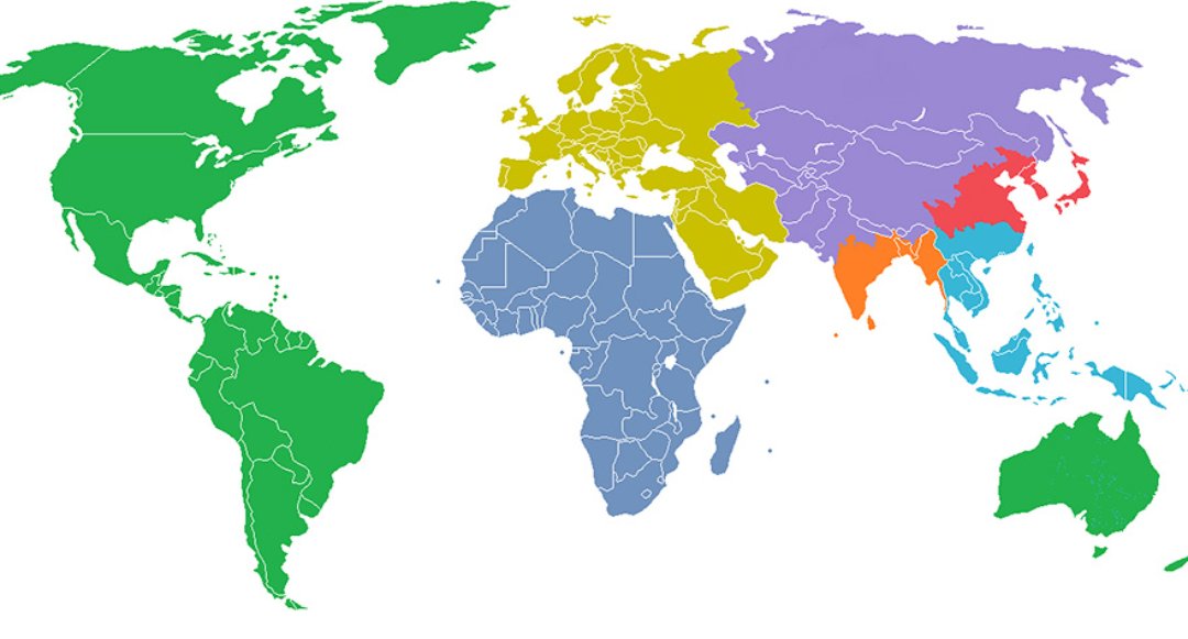
Using another projection would confuse the issue for non-map nerds. While there are problems with the Mercator Projection, it is what most people are familiar with. For example, showing a projection with Africa sized correctly with the Americas would confuse a lot of people who would think the underlying map was wrong.
On Windows 10, you can go to the Settings app > Ease of Access > Color & high contrast and choose color filters for deuteranopia, protanopia, tritanopia, grayscale, inverted, and grayscale inverted.
This projection looks to be either Robinson or Winkel-Tripel – both of which roughly do preserve area ratios.
Which is why all Wikis use these projections, or variations thereof, as standard base map (and it looks as if he just took at Wiki base map and colored it)
Of course, the internet is fantastic for pedantic nitpicking.
While we're on the subject of map projections, I would suggest taking a look at the Authagraph projection.[0] It preserves the size and shapes of all the continents while simultaneously giving the viewer vertigo.
Yeah that's pretty glaring. Even when the map is centered over Brazil, it's still super wide. Is Brazil really that wide, or is this just another super-imperfect projection that wildly distorts the real shape of land?
The population of Australia is just a rounding error on a map like this. The map's creator had quite a bit of freedom to put it wherever they wanted. The divisions on the map follow political and cultural boundaries, so putting Australia in the same group as Canada is defensible, if arguable.
Can't help but look at the density of regions like India and think it will brew trouble. I wonder what the correlation is between population density and violence, I imagine quite strong.
There's no correlation: Singapore and HK have some of the highest population density in the world, and have a low crime rate. Checking the list of countries by density[1] and then by violent crimes[2] will confirm that. India is quite violent, but for different reasons.
It's not violent like countries caught in the drug wars, but a single number fails to give the whole picture: in India a lot of the violence is targeting lower castes and religious minorities (Muslims, Christians, Sikhs)[1], sometimes with the (more or less overt) approval of the current ruling party (BJP -- Hindu nationalists). A recent shocking example is the gang rape and murder of an 8 year old Muslim girl: although most of the country was horrified by this, some of the demonstrations were in favour of the accused, and for the charges to be dropped[2].
So yes, when the ruling party basically deliberately targets minorities, I would qualify that country as "quite violent".
In all fairness, back in the old days, you really had to watch your step in HK. It had more than its fair share of crime. Far more. But this was in the 80's and early 90's.
They had an anti-crime and anti-corruption campaign, and of course there was the handover. So obviously crime dissipated as a result. But it was really bad in the old days.
I don't really know much about Singapore. I've never been there. That said, if crime is low, I'd imagine there were, at least for a time, exceedingly strict punishments for lawbreakers given the population density.
You are correct about HK (in fact I think the higher crime rate was much older that just the 80s and dated back to the 50s and mass emigration caused by the successive troubles in the mainland). I do think it's a great story, as it demonstrates an administration can completely turn around a police force from utter corrupt to highly professional in around a decade. In Western countries where the worldview is often 'static' it's also a good reminder that societies can change quickly.
And yes in Singapore the laws (and their enforcement) are much more strict.
Hong Kong started phasing out leaded gas around 1992; so you would expect a drop in crime rates about 2004 or so. And of course that's exactly what the statistics show.
I forget where I originally saw this (perhaps Reddit).